Rwenzori Mountains National Park – The Mountains of the Moon
Rwenzori Mountains National Park often linked to the Mountains of the Moon of ancient maps, and for a long time they were as mythical as they were real. They are real enough.
On the western edge of Uganda, on the border with the Democratic Republic of Congo, six ranges rise from steamy lowlands to ice-capped peaks, and the highest, Margherita Peak on Mount Stanley, reaches 5,109 metres, making it Uganda’s highest point and, in one table, Africa’s third-highest summit.
This guide explains the Rwenzori for travellers deciding whether and how to trek. It covers the park and its status, the two main summit routes, the shorter hikes for those who do not want to summit, what treks cost and what park fees apply, fitness and acclimatisation, what to pack, the mountain’s culture and wildlife, the best months, how to get there, a short current health note and the mistakes to avoid.
Rwenzori Mountains National Park at a Glance
| Question | Short Answer |
| Where | Western Uganda, on the border with the Democratic Republic of Congo, with trailheads near Kasese and Kilembe |
| Size and status | About 1,000 square kilometres; a national park since 1991 and a UNESCO World Heritage Site since 1994 |
| Highest point | Margherita Peak on Mount Stanley, 5,109 metres |
| Main routes | The Central Circuit, usually 7 days, and the Kilembe Trail, usually 8 days |
| Park fee | About US$35 per person per day for foreign non-residents, US$25 for residents and US$5 for children |
| Package price | From about US$1,400 for the Central Circuit and US$1,705 for the Kilembe Trail |
| Best months | June to August and December to March |
The Rwenzori are not for casual walkers. They reward fitness, patience and waterproofs, and they reward them well.
The Mountains and Their Setting
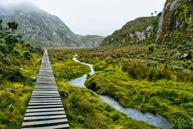
The Rwenzori are not a single volcano, like Kilimanjaro or Mount Kenya, but a group of six ranges. The highest is Mount Stanley, whose summit is Margherita Peak at 5,109 metres, followed by Mount Speke at 4,890 metres, Mount Baker at about 4,844 metres and, among the other peaks named in guides, Weismann’s Peak at 4,620 metres. The name is said to mean rain maker in the language of the Bakonjo people who live on the lower slopes, and the mountains are very wet. One page says Henry Morton Stanley popularised the name in 1888.
The park covers about 1,000 square kilometres and was gazetted as a national park in 1991, with UNESCO World Heritage inscription following in 1994. Its high valleys hold afro-alpine vegetation found in few places in the world, and its glaciers, while shrinking, still crown the highest peaks. Our separate guide to Uganda’s national parks explains where the Rwenzori fit among the ten.
The Two Summit Routes
| Route | Start and Direction | Duration | Character | Package Price |
| Central Circuit | The north, from about 1,600 metres | Usually 7 days, with a 6-day version of about 58 kilometres and a 5-day short version | The classic, longest and most famous route; five ecological zones; glacier crossing with crampons and an ice axe | From about US$1,400 |
| Kilembe Trail | The south, from Kilembe | Usually 8 days | A scenic summit approach, with more time to acclimatise | From about US$1,705 |
Both routes need a minimum of seven to eight days for safe acclimatisation to Margherita Peak, according to guides. Operators describe the climb as challenging and technical because of the glacier crossing, and a guide is required. Our separate guide to Uganda safari tours explains how to add a Rwenzori trek to a wider trip.
Shorter Hikes for Those Who Do Not Want to Summit
| Hike | Duration | What It Offers | Reported Price |
| Mutinda Lookout | 4 days on the Kilembe Trail | Views from about 3,975 metres across the valleys | From about US$645 |
| Rwenzori waterfalls hike | 4 days on the Kilembe Trail | A walk past waterfalls and through forest | From about US$615 |
| Short Central Circuit | 5 days | A fast approach to Margherita Peak | About US$1,200 |
| Weismann Peak | 6 days | A trek to a high peak at 4,620 metres | Confirm with operators |
| Four peaks expedition | 10 days | Margherita, Speke, Baker and Weismann’s peaks | US$1,590 plus park fees of US$35 per night in one guide |
| Day and short walks | A day or two | Foothill walks such as Ruboni Hill and village visits | Priced by operators |
The four-day treks are the best choice for travellers who want to see the Rwenzori without a glacier crossing, and they give a real taste of the forests and the cloud. Our separate guide to community-based tourism in Uganda explains the foothill walks.
What It Costs: Park Fees and Packages
| Item | Reported Cost | Notes |
| Park fee, foreign non-resident | About US$35 per person per day | US$25 for foreign residents and US$5 for children in one guide |
| A 7-day Central Circuit | 7 x US$35 = US$245 in park fees | On top of the package, or included in all-inclusive packages |
| An 8-day Kilembe Trail | 8 x US$35 = US$280 in park fees | As above |
| Operator package, Central Circuit | From about US$1,400 | Includes guides, porters, huts, meals, rubber boot hire and technical equipment, according to operators |
| Operator package, Kilembe Trail | From about US$1,705 | As above |
| All-in estimates | About US$1,250 to US$3,500 per person | Depending on days, group size and operator |
Packages that quote the park fee separately can look cheaper than all-inclusive ones, so compare like with like. One guide compares all-in Rwenzori costs of about US$1,650 to US$2,100 per person with US$2,200 to US$3,500 for a well-run mid-range Kilimanjaro climb. Our separate guide to Uganda safari prices explains how to read a quote.
Fitness, Acclimatisation and Difficulty
- The Central Circuit and Kilembe Trail are long, wet and steep, with several days of eight hours or more.
- The summit day includes a rocky scramble and a glacier crossing with crampons and an ice axe, under the supervision of a guide.
- Seven to eight days are needed to acclimatise safely to 5,109 metres.
- Train with long hill walks and stair work in the weeks before, and carry a loaded pack in training.
- Tell your guide how you feel, and accept turning back if altitude sickness appears.
- Anyone with heart, lung or knee conditions should speak to a doctor before booking.
The Rwenzori are easier than some mountains in terms of altitude gain per day and harder in terms of mud, rain and technical sections. Our separate guide to Mount Elgon explains a gentler alternative.
What to Pack
| Item | Why |
| Waterproof jacket and trousers | The mountains are very wet |
| Warm layers, hat and gloves | Nights and summit days are cold |
| Sturdy waterproof boots, with rubber boots often provided | Deep mud on the lower trails |
| Gaiters | Keep mud out of boots |
| Head torch and spare batteries | For huts and the summit start |
| Sleeping bag and a dry bag | Huts are simple, and everything gets damp |
| Sun protection and sunglasses | Strong sun and glare at altitude |
| Technical equipment | Crampons, an ice axe and a harness are usually provided by operators |
Pack everything in waterproof bags. Our separate guide to what to pack for a Uganda safari and the gorilla trekking packing guide give general lists, and mountain trips need extra cold-weather and wet-weather kit.
People, Plants and Wildlife
The Bakonjo, or Bakonzo, people live on the lower slopes and have long been the guides and porters of the mountains. Their culture is part of the Rwenzori experience, and community walks such as the Ruboni Hill walk and the Rwenzori Turaco View village walk give a gentle introduction. Hiring local guides and porters supports families who depend on the park.
The mountain’s plants are its most striking life: giant heather, tree ferns, moss-draped trees and the giant lobelias and senecios of the high valleys. Wildlife is secretive, though birds, monkeys and, at lower altitudes, forest animals are present. Our separate guide to birding safaris in Uganda explains the Albertine Rift endemics found in the forests.
Best Time to Go, Getting There and a Current Health Note
| Topic | What to Know |
| Best months | June to August and December to March, when rainfall is lower |
| Wetter months | March to May and the short rains, with deeper mud and more cloud |
| Getting there | By road from Kampala to Kasese or Kilembe, a long drive, or from Queen Elizabeth or Fort Portal |
| Combine with | Queen Elizabeth, Kibale and Semuliki |
| Health | A yellow fever certificate is mandatory for Uganda and malaria is present at lower altitudes; Uganda says it is currently Ebola-free and restricts travel from the Democratic Republic of Congo, which borders the park; the outbreak, centred on Ituri province, has also reached North Kivu, across the border from this region, so check your government’s advice and your operator’s plans for the border area |
Frequently Asked Questions
How high is Margherita Peak?
5,109 metres, the highest point in Uganda, on Mount Stanley.
How long does the summit trek take?
Seven days on the Central Circuit and eight on the Kilembe Trail, usually.
How much does it cost?
Packages start at about US$1,400 for the Central Circuit and US$1,705 for the Kilembe Trail, plus park fees of about US$35 a day where not included.
Can I hike without summiting?
Yes. Four-day treks to Mutinda Lookout and the waterfalls start at about US$615 to US$645.
When is the best time to trek?
June to August and December to March.